
Meyer Boulevard Study Overview
The purpose of the Meyer Boulevard study is to evaluate ways to calm traffic along the corridor to improve safety for all users. The project included analyzing the corridor and developing a concept level plan for improvements for the section from Ward Parkway to just west of Troost Avenue. As a part of this study, a "road diet" (reduction in through travel lanes) is being evaluated which would better define parking areas and allow the addition of on-street bike lanes. The study is also evaluating possible changes to Brookside Boulevard between Meyer and 63rd Street to add on-street parking on the west side of the street in order to provide much needed parking for the adjacent Border Star School and the Brookside shopping district, and further calm area traffic and improve public safety. The study is also evaluating a way to extend the Trolley Trail north of Meyer along Brookside Boulevard, and providing a safe crossing at Meyer.
This project is being led by the Kansas City Parks and Recreation Department with the goal to make Meyer Boulevard safe and attractive to all users – pedestrians, bicyclists and automotive traffic. The City contracted with a team professional traffic engineers, civil engineers, planners and landscape architects from R^3C DESIGN GROUP, VIREO, and Walter P Moore and Associates, Inc.
Project Exhibits and Concept Plans
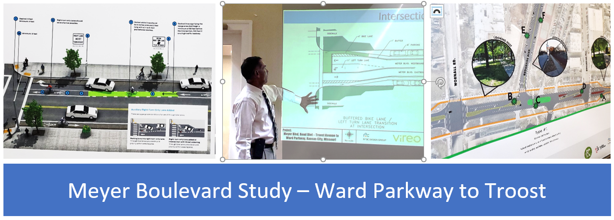
The following exhibits and concept plans were developed over the last year and presented at a public meeting Thursday, June 20th from 6 to 8 pm at St. Peter's Parish on Meyer Boulevard. Following area a brief summary of project boards presented at the meeting, along with links that redirects you to the files on Google Drive. Please note that some of the files are large and may take a few seconds to a minute or more to load (thanks in advance for your patience).
- Walkability Board PDF - Shows a heat map of the cumulative scoring of walking conditions in the corridor. The scoring is based on Kansas City’s Walkability Plan, prepared for the City Planning & Development Department available at: https://data.kcmo.org/Area-Plans/Kansas-City-Walkability-Plan/4xta-z2pq
- Typical Road Sections - Shows existing road cross sections on Meyer Boulevard in addition to proposed intersection treatments and the mid-block cross sections with a protected bike lane and a buffered bike lane. The buffered bike lane option is preferred because of the numerous driveways and ability to increase visibility of the cyclist.
- NACTO Guidelines - Shows different options for treatment of bicycle lanes from the Urban Bikeway Design Guide, published by the National Association of City Transportation Officials (NACTO) and available at: https://nacto.org/publication/urban-bikeway-design-guide/
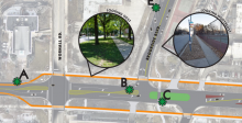
- Meyer Concept – Baltimore to Pennsylvania - Shows concept plans for Meyer between Baltimore and Pennsylvania, including typical cross sections for the more commercial area from Brookside Plaza/Wyandotte Street to Wornall Road, versus more residential areas to the east and west. Included in this section is the off-street cycle track.
- Meyer Concept Pavement Markings - Shows the conceptual pavement marking plans for the entire corridor from west of Troost Avenue to east of Ward Parkway.
- Meyer Public Meeting Map Comments - Shows the comments received on the plan sheets during the public meeting held on June 20, 2019. These comments are in addition to other written and verbal comments from the public meeting and separately stakeholder meetings.
Share Comments, Suggestions and Questions
During the public meeting, the City and project team representatives presented a project summary and answered questions about the exhibits. Attendees were encouraged to mark notes and suggestions on the concept plans and leave other comments. In addition, project representatives noted comments and questions shared verbally throughout the evening. Comments and suggestions were collected from area stakeholders during the project. The collective comments will be used to help guide final concept revisions.
Couldn't make the meeting or have additional comments? There’s still time to comment. Click here to be redirected to a Google form where you can leave comments, suggestions, and questions through Friday, July 26, 2019. Name and a valid email address are required for verification and so the team and City can follow up with additional questions or information if needed. Thank you in advance for taking the time to share your opinion.
Next Steps
After evaluating public input, the City and project team will refine concepts. The revised concepts will be presented to the Kansas City Parks and Recreation Department for approval before proceeding to preliminary and final engineering plans. No City funds have been allocated at this time, but the Parks Department anticipates funding and starting design later this year. During design, concepts will be further refined and there will additional opportunities for public input prior to final approval and implementation. Once approved, the City and community partners will seek funding for the project as a whole or in phases.
Thank you for your time and interest in improving Meyer Boulevard!